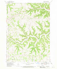
1968 Map of Church
USGS Topo · Published 1970About this map
Lansing Ridge defines the northern reaches of this Allamakee County landscape, where the high ground once supported a concentrated network of early settlements and rural parish life. The map reveals a high density of religious centers that served the surrounding farmsteads in the late 1960s, including West Paint Creek Ch, Old West Paint Creek Ch, and Old East Paint Creek Ch near the crossroads of Dalby. This concentration of namesake structures, alongside the village of Church, highlights the region's strong community identity tied to its land-use patterns.
Find a feature on this map
31 named features on this map. Tap any name to fly to it.
Don’t see what you’re looking for? This feature index may not catch every label — zoom into the map to look around manually.
Map Details
Editions of this 1968 Church Map
2 editions found
Other maps of this area

1903 · Waukon
USGS Topo · 1:125,000

1929 · Ferryville
USGS Topo · 1:62,500

1929 · Prairie Du Chien
USGS Topo · 1:62,500

1932 · Ferryville
USGS Topo · 1:62,500

1932 · Prairie Du Chien
USGS Topo · 1:62,500

1958 · La Crosse
USGS Topo · 1:250,000

1961 · La Crosse
USGS Topo · 1:250,000

1965 · La Crosse
USGS Topo · 1:250,000

1966 · Ferryville
USGS Topo · 1:62,500
1967 · Prairie Du Chien
USGS Topo · 1:62,500