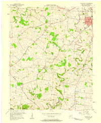
1956 Map of Church Hill
USGS Topo · Published 1958About this map
Hopkinsville anchors the northeastern corner of this Christian County landscape, where the residential expansion of Canton Heights meets the County Fairgrounds. Moving southwest, the terrain transitions into a dense network of rural communities and congregational landmarks that defined mid-century life in this part of Kentucky. The area is characterized by numerous small churches and rural schools, including South Union Ch near the eponymous Church Hill settlement, and the Walnut Grove Sch further north. Transport and water dominate the geography, with the Illinois Central railroad cutting through the northern reaches while the winding course of the Little River carves through the southern half of the map, crossed by the distinctively named Striped Bridge. The map captures a moment before modern consolidation, preserving the locations of community anchors like Hebron Ch and Gee Sch.
Find a feature on this map
35 named features on this map. Tap any name to fly to it.
Don’t see what you’re looking for? This feature index may not catch every label — zoom into the map to look around manually.
Map Details
Editions of this 1956 Church Hill Map
2 editions found
Other maps of this area

1944 · Clarksville
USGS Topo · 1:50,000

1950 · Caledonia
USGS Topo · 1:24,000

1951 · Church Hill
USGS Topo · 1:24,000

1951 · Caledonia
USGS Topo · 1:24,000

1951 · Hopkinsville
USGS Topo · 1:24,000

1951 · Roaring Spring
USGS Topo · 1:24,000

1951 · Herndon
USGS Topo · 1:24,000

1951 · Oak Grove
USGS Topo · 1:24,000

1952 · Pleasant Green Hill
USGS Topo · 1:24,000

1952 · Kelly
USGS Topo · 1:24,000