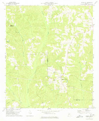
1973 Map of Church Hill
USGS Topo · Published 1974About this map
Kinchafoonee Creek and Lanahassee Creek snake through the borderlands of Marion and Webster Counties, defining a rural Georgia landscape during the early 1970s. The settlement at Church Hill serves as a local focal point, surrounded by a high density of country churches that suggest a deeply rooted social fabric. Landmarks such as Shiloh-Marion-Church Hill Ch, New Friendship Ch, and Evans Chapel are scattered across the terrain, alongside older sites like Old Union Cem.
Find a feature on this map
20 named features on this map. Tap any name to fly to it.
Don’t see what you’re looking for? This feature index may not catch every label — zoom into the map to look around manually.
Map Details
Editions of this 1973 Church Hill Map
2 editions found
Other maps of this area

1949 · Glen Alta
USGS Topo · 1:24,000

1950 · Buena Vista
USGS Topo · 1:24,000

1950 · Buena Vista
USGS Topo · 1:62,500

1955 · Buena Vista
USGS Topo · 1:24,000
1955 · Glen Alta
USGS Topo · 1:24,000
1955 · Buena Vista
USGS Topo · 1:62,500

1955 · Phenix City
USGS Topo · 1:250,000

1957 · Phenix City
USGS Topo · 1:250,000

1958 · Phenix City
USGS Topo · 1:250,000

1971 · Tazewell South
USGS Topo · 1:24,000