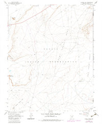
1968 Map of Church Rock
USGS Topo · Published 1983About this map
Church Rock Valley dominates this high-desert landscape within the Navajo Indian Reservation, defined by its striking vertical formations and expansive plateaus. The prominent spire of Church Rock serves as a central landmark near the Pipeline that traverses the northern reaches. This 1960s survey, updated with 1980s aerial revisions, captures a network of unimproved dirt roads and trails connecting remote landmarks like Gray Point and the dramatic Facing Red Points. The geography is characterized by massive elevated features, including Baby Rocks Mesa and the wide expanse of Small White Mesa Flat. Water is scarce in this arid environment, represented by the winding Tyende Creek in the southeast corner. Sparse human activity is evidenced by a few scattered infrastructure points, such as a Borrow Pit and isolated wells or drill holes, highlighting the area's role as a vast, open territory within the reservation.
Find a feature on this map
16 named features on this map. Tap any name to fly to it.
Don’t see what you’re looking for? This feature index may not catch every label — zoom into the map to look around manually.
Map Details
Editions of this 1968 Church Rock Map
3 editions found
Other maps of this area

1883 · Marsh Pass
USGS Topo · 1:250,000

1892 · Marsh Pass
USGS Topo · 1:250,000

1892 · Canyon De Chelly
USGS Topo · 1:250,000

1952 · Dinnehotso
USGS Topo · 1:62,500

1952 · Agathla Peak 1 SE
USGS Topo · 1:24,000

1952 · Setsiltso Springs 2 SW
USGS Topo · 1:24,000

1952 · Agathla Peak
USGS Topo · 1:62,500

1952 · Agathla Peak 1 SW
USGS Topo · 1:24,000

1954 · Shiprock
USGS Topo · 1:250,000

1956 · Marble Canyon
USGS Topo · 1:250,000