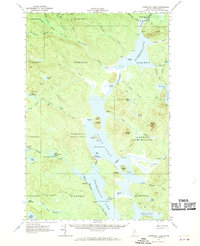
1962 Map of Churchill Lake
USGS Topo · Published 1970About this map
Churchill Lake and Eagle Lake form the core of this North Woods survey, linked by the complex Thoroughfare water system. The map reveals the area's industrial past through remnants like the Abandoned Tramway at the State Forest Service Camp and an Old Railroad Grade near Chamberlain Lake. These features, along with an Abandoned Submarine Cable, point to a specialized infrastructure designed to navigate this lacustrine landscape before the expansion of recreational sites like Crows Nest Campground or the Zeigler Campground.
Find a feature on this map
77 named features on this map. Tap any name to fly to it.
Don’t see what you’re looking for? This feature index may not catch every label — zoom into the map to look around manually.
Map Details
Editions of this 1962 Churchill Lake Map
3 editions found
Other maps of this area

1932 · Umsaskis Lake
USGS Topo · 1:48,000

1932 · Musquacook Lakes
USGS Topo · 1:48,000

1935 · Umsaskis Lake
USGS Topo · 1:62,500

1935 · Musquacook Lakes
USGS Topo · 1:62,500

1953 · Telos Lake
USGS Topo · 1:62,500

1954 · Chesuncook
USGS Topo · 1:62,500

1954 · Spider Lake
USGS Topo · 1:62,500

1954 · Caucomgomoc Lake
USGS Topo · 1:62,500

1954 · Churchill Lake
USGS Topo · 1:62,500

1954 · Allagash Lake
USGS Topo · 1:62,500