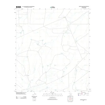
2013 Map of Cibolo Ranch
USGS Topo · Published 2013About this map
Cibolo Ranch and Borden Camp serve as the primary hubs of activity in this arid portion of Webb County. The landscape is defined by an intricate network of livestock tanks and seasonal watercourses, reflecting the vital ranching infrastructure required to sustain life in the South Texas brush country. Key drainage systems like Chacon Cr and San Ygnacio Cr snake across the terrain, while the naming of water sources such as Kuykendall Tank and De Cavasos Tank suggests a legacy of long-standing family landholdings. Movement through the area is facilitated by ranch roads like San Ignacio Rd, connecting isolated cattle tanks and seasonal springs like El Pato Spring. This map provides a detailed view of the water-management strategies and grazing patterns that characterize modern large-scale ranching operations in the Rio Grande basin.
Find a feature on this map
29 named features on this map. Tap any name to fly to it.
Don’t see what you’re looking for? This feature index may not catch every label — zoom into the map to look around manually.
Map Details
Editions of this 2013 Cibolo Ranch Map
This is the sole edition of this map. No revisions or reprints were ever made.
Other maps of this area

1937 · Aguilete Creek
USGS Topo · 1:62,500

1956 · Becerra
USGS Topo · 1:62,500

1956 · Laredo East
USGS Topo · 1:62,500

1956 · Webb
USGS Topo · 1:62,500

1956 · Laredo
USGS Topo · 1:250,000

1965 · Orvil
USGS Topo · 1:24,000

1965 · Cibolo Ranch
USGS Topo · 1:24,000

1965 · Tios Creek
USGS Topo · 1:24,000

1965 · Laredo East
USGS Topo · 1:24,000
1980 · Callaghan Ranch SE
USGS Topo · 1:24,000