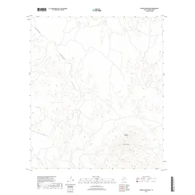
2019 Map of Cienega Mountains
USGS Topo · Published 2019About this map
The Cienega Mountains dominate this high-elevation landscape in Presidio County, providing a stark look at the arid topography of the Big Bend region. The terrain is defined by complex drainage systems, with Cienega Creek and Tortolo Cr carving paths through the foothills. Unlike many western surveys that show dense settlement, this area remains characterized by its openness and limited infrastructure. Transportation is restricted to a few established routes such as Charco Bracero Creek Rd and Cienega Mountain Rd, which provide access to this remote corner of West Texas. The drainage patterns of Sauceda Cr further illustrate the watershed of the high desert, offering a clear view of the natural watercourses that have historically dictated movement and land use in this part of the state.
Find a feature on this map
7 named features on this map. Tap any name to fly to it.
Don’t see what you’re looking for? This feature index may not catch every label — zoom into the map to look around manually.
Map Details
Editions of this 2019 Cienega Mountains Map
This is the sole edition of this map. No revisions or reprints were ever made.
Other maps of this area

1896 · Shafter
USGS Topo · 1:125,000

1959 · Presidio
USGS Topo · 1:250,000

1965 · Presidio
USGS Topo · 1:250,000

1978 · La Boquilla
USGS Topo · 1:24,000

1983 · Shafter
USGS Topo · 1:24,000

1983 · Plata
USGS Topo · 1:24,000

1983 · Cienega Mountains
USGS Topo · 1:24,000
1983 · Casa Piedra
USGS Topo · 1:24,000
1983 · Cerros Prietos
USGS Topo · 1:24,000
1983 · Cieneguita
USGS Topo · 1:24,000