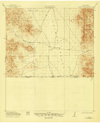
1918 Map of Cienega Springs
USGS Topo · Published 1946About this map
The international boundary between the United States and Mexico defines the southern edge of this 1917–1918 survey of Hidalgo County. The landscape is dominated by the broad Animas Valley, flanked by the Peloncillo Mts and Guadalupe Mts to the west and the Animas Mountains to the east. Human presence is scattered across this high desert terrain, marked by remote outposts like Cloverdale and the Lang Ranch. Water sources were critical to the survival of these early settlements, as evidenced by the mapping of Birch Springs, Fitzpatricks Well, and Cienega Springs. The survey also highlights important transit corridors through the mountain ranges, including Guadalupe Pass and San Luis Pass, which connected these isolated ranching areas. Portions of the Coronado National Forest are visible, showing the early extent of federal land management in this border region during the First World War era.
Find a feature on this map
21 named features on this map. Tap any name to fly to it.
Don’t see what you’re looking for? This feature index may not catch every label — zoom into the map to look around manually.
Map Details
Editions of this 1918 Cienega Springs Map
3 editions found
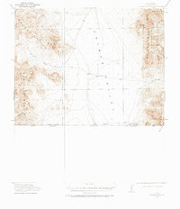
Other maps of this area

1917 · Chiricahua
USGS Topo · 1:125,000

1917 · Antelope Wells
USGS Topo · 1:62,500

1918 · Walnut Wells
USGS Topo · 1:62,500

1918 · Cienega Springs
USGS Topo · 1:62,500

1918 · Animas Peak
USGS Topo · 1:62,500

1919 · Antelope Wells
USGS Topo · 1:62,500

1919 · Perilla
USGS Topo · 1:125,000

1919 · Chiricahua
USGS Topo · 1:125,000

1920 · Animas Peak
USGS Topo · 1:62,500

1922 · McDonald
USGS Topo · 1:62,500