
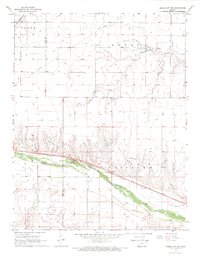
1968 Map of Cimarron
USGS Topo · Published 1969About this map
The Cimarron townsite serves as the central hub of this late-1960s Kansas landscape, situated along the north bank of the Arkansas River. The settlement's infrastructure includes the local High Sch, a Fairground, and the Cimarron Airport to the north. Transportation and irrigation define the local economy, as seen in the prominent Atchison Topeka and Santa Fe railroad corridor and the complex network of waterways, including an Abandoned Canal and an active Canal system. Beyond the town center, the terrain is dotted with agricultural landmarks like Gravel Pits and the Ch of God in Christ. In the far eastern reach, the small community of Wettick sits near the headwaters of the South Fork Buckner Creek, illustrating the dispersed nature of rural Gray County during this era.
Find a feature on this map
22 named features on this map. Tap any name to fly to it.
Don’t see what you’re looking for? This feature index may not catch every label — zoom into the map to look around manually.
Map Details
Editions of this 1968 Cimarron Map
This is the sole edition of this map. No revisions or reprints were ever made.
Other maps of this area

1892 · Dodge
USGS Topo · 1:125,000

1955 · Dodge City
USGS Topo · 1:250,000

1958 · Dodge City
USGS Topo · 1:250,000

1959 · Dodge City
USGS Topo · 1:250,000

1968 · Cimarron NW
USGS Topo · 1:24,000

1968 · Ingalls
USGS Topo · 1:24,000

1968 · Dodge City NW
USGS Topo · 1:24,000

1968 · Montezuma NW
USGS Topo · 1:24,000

1968 · Cimarron NE
USGS Topo · 1:24,000
1968 · Dodge City SW
USGS Topo · 1:24,000