
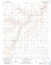
1968 Map of Dodge City NW
USGS Topo · Published 1969About this map
Buckner Creek meanders across this rural Western Kansas landscape, defining the drainage patterns through the townships of South Roscoe, Foote, and Royal. Surveyed in the late 1960s, the map highlights a terrain shaped by water management and resource extraction, marked by a prominent Pipeline cutting across the southeastern corner and isolated water sources like a named Spring and Well. The confluence where the South Fork meets the main creek bed illustrates the natural erosion of the High Plains. This map is particularly notable for capturing the convergence of three counties—Gray, Hodgeman, and Ford—revealing how early political boundaries were overlaid across the open prairie.
Find a feature on this map
11 named features on this map. Tap any name to fly to it.
Don’t see what you’re looking for? This feature index may not catch every label — zoom into the map to look around manually.
Map Details
Editions of this 1968 Dodge City NW Map
2 editions found
Other maps of this area

1892 · Dodge
USGS Topo · 1:125,000

1955 · Dodge City
USGS Topo · 1:250,000

1955 · Scott City
USGS Topo · 1:250,000

1958 · Dodge City
USGS Topo · 1:250,000

1958 · Scott City
USGS Topo · 1:250,000

1959 · Dodge City
USGS Topo · 1:250,000

1968 · Dodge City NE
USGS Topo · 1:24,000

1968 · Cimarron
USGS Topo · 1:24,000

1968 · Cimarron NE
USGS Topo · 1:24,000

1968 · Dodge City
USGS Topo · 1:24,000