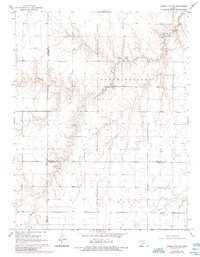
1968 Map of Dodge City NW
USGS Topo · Published 1984About this map
Buckner Creek and its tributary, the South Fork Buckner Creek, carve a distinct dendritic drainage pattern through this portion of the Kansas plains. The landscape is defined by its agricultural and administrative divisions, where the tri-county junction of Gray, Hodgeman, and Ford counties meets. Surveyed in the mid-1960s with early 1980s updates, the map reflects a rural economy dependent on water management and energy infrastructure. The presence of a Spring along the south fork and an isolated Well in the northwest corner highlights the importance of localized water sources in this environment. Named regions such as South Roscoe, Foote, and Royal denote historical townships or districts, while a modern Pipeline cuts across the southeast, signaling the industrial overlay on traditional ranching or farming lands.
Find a feature on this map
11 named features on this map. Tap any name to fly to it.
Don’t see what you’re looking for? This feature index may not catch every label — zoom into the map to look around manually.
Map Details
Editions of this 1968 Dodge City NW Map
2 editions found
Other maps of this area

1892 · Dodge
USGS Topo · 1:125,000

1955 · Dodge City
USGS Topo · 1:250,000

1955 · Scott City
USGS Topo · 1:250,000

1958 · Dodge City
USGS Topo · 1:250,000

1958 · Scott City
USGS Topo · 1:250,000

1959 · Dodge City
USGS Topo · 1:250,000

1968 · Dodge City NE
USGS Topo · 1:24,000

1968 · Dodge City NW
USGS Topo · 1:24,000

1968 · Cimarron
USGS Topo · 1:24,000

1968 · Cimarron NE
USGS Topo · 1:24,000