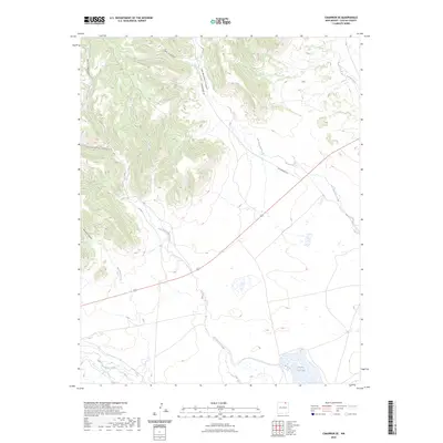
2023 Map of Cimarron SE
USGS Topo · Published 2023About this map
Cerrososo Canyon and Van Bremmer Canyon define the broken, high-altitude landscape of this Colfax County region. The terrain is marked by a series of deep drainages including Coal Canyon and Bat Canyon that feed into lower creek systems. Water management and natural hydrology are central to the area's character, with Van Bremmer Creek and Cerrososo Creek winding through the flats toward the Vermejo River. In the southern portion of the sheet, Ponil Creek and the notable Number Two Lake provide distinct geographic anchors in an otherwise sparse landscape. Transport through this high country is limited to a few established routes such as Van Bremmer Rd and the backcountry access of FR 1950. The map illustrates a contemporary view of New Mexico's northern high plains and canyonlands where cattle ranching and resource management continue to shape land use.
Find a feature on this map
13 named features on this map. Tap any name to fly to it.
Don’t see what you’re looking for? This feature index may not catch every label — zoom into the map to look around manually.
Map Details
Editions of this 2023 Cimarron SE Map
This is the sole edition of this map. No revisions or reprints were ever made.
Other maps of this area

1915 · Koehler
USGS Topo · 1:62,500

1917 · Koehler
USGS Topo · 1:62,500

1954 · Raton
USGS Topo · 1:250,000

1955 · Cimarron
USGS Topo · 1:62,500

1956 · Miami
USGS Topo · 1:62,500

1958 · Raton
USGS Topo · 1:250,000

1965 · Springer Lake
USGS Topo · 1:24,000

1971 · Saltpeter Mountain
USGS Topo · 1:24,000
1971 · Colfax
USGS Topo · 1:24,000

1981 · Springer
USGS Topo · 1:100,000