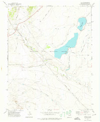
1971 Map of Colfax
USGS Topo · Published 1974About this map
The historical Beaubien and Miranda Grant dominates this landscape of northeastern New Mexico, where the high plains meet the foothills of the Sangre de Cristo Mountains. The settlement of Colfax and the neighboring area of Maxwell are positioned along the critical transportation corridors that defined the region’s development. The Santa Fe Trail cuts across the northeastern corner, marking the enduring path of westward expansion, while the active tracks of the Atchison Topeka and Santa Fe railroad run parallel to an Old Railroad Grade, showing the evolution of industrial transit.
Find a feature on this map
15 named features on this map. Tap any name to fly to it.
Don’t see what you’re looking for? This feature index may not catch every label — zoom into the map to look around manually.
Map Details
Editions of this 1971 Colfax Map
This is the sole edition of this map. No revisions or reprints were ever made.
Other maps of this area

1915 · Koehler
USGS Topo · 1:62,500

1917 · Koehler
USGS Topo · 1:62,500

1954 · Raton
USGS Topo · 1:250,000

1955 · Cimarron
USGS Topo · 1:62,500

1956 · Miami
USGS Topo · 1:62,500

1958 · Raton
USGS Topo · 1:250,000

1965 · French
USGS Topo · 1:24,000

1965 · Springer Lake
USGS Topo · 1:24,000

1971 · Saltpeter Mountain
USGS Topo · 1:24,000
1971 · Koehler
USGS Topo · 1:24,000