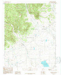
1987 Map of Cimarron SE
USGS Topo · Published 1987About this map
The Beaubien and Miranda Grant (Maxwell) encompasses much of this northeastern New Mexico landscape, a territory defined by high-elevation drainage systems and historic transportation routes. Evidence of early transit is clear through the presence of the Santa Fe Trail cutting across the southeastern corner, alongside an Old Railroad Grade and the active A T & S F rail line. The terrain is deeply incised by watercourses such as Van Bremmer Creek, Cerrososo Creek, and the Vermejo River, which flow from canyons like Coal Canyon and Encinosa Canyon. In the lower plains, the No 2 Lake and various ditches suggest the localized management of water for ranching or small-scale industry during the late twentieth century. This survey preserves the spatial relationship between these natural canyons and the legacy of large-scale land grants in Colfax County.
Find a feature on this map
18 named features on this map. Tap any name to fly to it.
Don’t see what you’re looking for? This feature index may not catch every label — zoom into the map to look around manually.
Map Details
Editions of this 1987 Cimarron SE Map
This is the sole edition of this map. No revisions or reprints were ever made.
Other maps of this area

1915 · Koehler
USGS Topo · 1:62,500

1917 · Koehler
USGS Topo · 1:62,500

1954 · Raton
USGS Topo · 1:250,000

1955 · Cimarron
USGS Topo · 1:62,500

1956 · Miami
USGS Topo · 1:62,500

1958 · Raton
USGS Topo · 1:250,000

1965 · Springer Lake
USGS Topo · 1:24,000

1971 · Saltpeter Mountain
USGS Topo · 1:24,000
1971 · Colfax
USGS Topo · 1:24,000

1981 · Springer
USGS Topo · 1:100,000