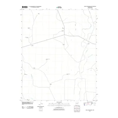
2010 Map of Circle Bar Ranch
USGS Topo · Published 2010About this map
Ute Creek winds through the high plains of Harding County, defining a landscape shaped by a century of ranching traditions. The namesake Circle Bar Ranch is situated near the creek's eastern banks, while the surrounding territory is dotted with numerous family-named landmarks and water sources. These features, including Grandma Mitchell Windmill, Salaza Windmill, and Ramon Windmill, indicate the enduring importance of groundwater management in this arid New Mexico environment. The terrain rises toward the Black Hills in the north and the slopes of Sandstone Mountain Windmill, while drainage follows natural features like Tequesquite Creek and the Arroyo de la Cejita. This 2010 survey reflects a region where infrastructure remains tied to large-scale landholdings and the seasonal flow of prairie waterways.
Find a feature on this map
19 named features on this map. Tap any name to fly to it.
Don’t see what you’re looking for? This feature index may not catch every label — zoom into the map to look around manually.
Map Details
Editions of this 2010 Circle Bar Ranch Map
This is the sole edition of this map. No revisions or reprints were ever made.
Other maps of this area

1954 · Tucumcari
USGS Topo · 1:250,000

1958 · Tucumcari
USGS Topo · 1:250,000

1969 · Gallegos NE
USGS Topo · 1:24,000

1969 · Salitre Canyon
USGS Topo · 1:24,000

1969 · Buffalo Springs
USGS Topo · 1:24,000

1973 · Bueyeros NE
USGS Topo · 1:24,000

1973 · Circle Bar Ranch
USGS Topo · 1:24,000
1973 · Indian Bathtub
USGS Topo · 1:24,000
1973 · Bueyeros
USGS Topo · 1:24,000
1973 · Albert
USGS Topo · 1:24,000