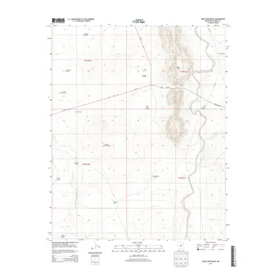
2013 Map of Circle Bar Ranch
USGS Topo · Published 2013About this map
The high plains of Harding County define this landscape, where the ranching economy is etched into the terrain through a dense network of water infrastructure. Named for the Circle Bar Ranch, the area is characterized by numerous wind-powered wells that support livestock across the open range. These include family-named landmarks such as Steele Windmill, Grandma Mitchell Windmill, and Ramon Windmill. The topography is dominated by the Black Hills, which rise prominently between the drainage systems of Tequesquite Cr and Arroyo de la Cejita. Transportation is limited to a few arterial routes like NM-102 and the Bravo Dome Hwy, highlighting the remote nature of these ranching operations in northeastern New Mexico. Local history is preserved in the names of landmarks like Sandstone Mountain Windmill and North Plaz Windmill, which signify the long-standing occupation of this arid landscape.
Find a feature on this map
26 named features on this map. Tap any name to fly to it.
Don’t see what you’re looking for? This feature index may not catch every label — zoom into the map to look around manually.
Map Details
Editions of this 2013 Circle Bar Ranch Map
This is the sole edition of this map. No revisions or reprints were ever made.
Other maps of this area

1954 · Tucumcari
USGS Topo · 1:250,000

1958 · Tucumcari
USGS Topo · 1:250,000

1969 · Gallegos NE
USGS Topo · 1:24,000

1969 · Salitre Canyon
USGS Topo · 1:24,000

1969 · Buffalo Springs
USGS Topo · 1:24,000

1973 · Bueyeros NE
USGS Topo · 1:24,000

1973 · Circle Bar Ranch
USGS Topo · 1:24,000
1973 · Indian Bathtub
USGS Topo · 1:24,000
1973 · Bueyeros
USGS Topo · 1:24,000
1973 · Albert
USGS Topo · 1:24,000