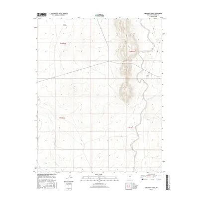
2017 Map of Circle Bar Ranch
USGS Topo · Published 2017About this map
Circle Bar Ranch and the isolated Steele Windmill define the human footprint in this corner of Harding County. This 2017 survey by the U.S. Geological Survey illustrates the ranching landscape of northeastern New Mexico, where water sources like Tequesquite Cr and the Arroyo de la Cejita dictate the placement of local infrastructure. The terrain is dominated by the elevations of the Black Hills, which rise prominently above the surrounding plains. Local connectivity is maintained through a sparse network of dirt and gravel routes, including BART Cross RD and Libby RD. This map provides a clear view of land management and drainage patterns in a high-desert environment, capturing the spatial relationship between namesake ranching operations and the natural landmarks that surround them.
Find a feature on this map
12 named features on this map. Tap any name to fly to it.
Don’t see what you’re looking for? This feature index may not catch every label — zoom into the map to look around manually.
Map Details
Editions of this 2017 Circle Bar Ranch Map
This is the sole edition of this map. No revisions or reprints were ever made.
Other maps of this area

1954 · Tucumcari
USGS Topo · 1:250,000

1958 · Tucumcari
USGS Topo · 1:250,000

1969 · Gallegos NE
USGS Topo · 1:24,000

1969 · Salitre Canyon
USGS Topo · 1:24,000

1969 · Buffalo Springs
USGS Topo · 1:24,000

1973 · Bueyeros NE
USGS Topo · 1:24,000

1973 · Circle Bar Ranch
USGS Topo · 1:24,000
1973 · Indian Bathtub
USGS Topo · 1:24,000
1973 · Bueyeros
USGS Topo · 1:24,000
1973 · Albert
USGS Topo · 1:24,000