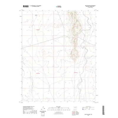
2023 Map of Circle Bar Ranch
USGS Topo · Published 2023About this map
Black Hills dominates the northeastern landscape of this Harding County quadrant, rising above the surrounding drainages. This high plains territory is defined by its intermittent watercourses, notably Tequesquite Creek in the west and Arroyo de la Cejita to the east. The presence of Steele Windmill in the northern section highlights the critical importance of groundwater management for ranching operations in this arid environment. Transportation across the township is facilitated by established ranch routes such as Bart Cross Rd and Libby Rd, which connect isolated sections of the Public Land Survey System. The map documents a sparsely populated but active agricultural landscape where topographical elevation and water access dictate the placement of local landmarks.
Find a feature on this map
11 named features on this map. Tap any name to fly to it.
Don’t see what you’re looking for? This feature index may not catch every label — zoom into the map to look around manually.
Map Details
Editions of this 2023 Circle Bar Ranch Map
This is the sole edition of this map. No revisions or reprints were ever made.
Other maps of this area

1954 · Tucumcari
USGS Topo · 1:250,000

1958 · Tucumcari
USGS Topo · 1:250,000

1969 · Gallegos NE
USGS Topo · 1:24,000

1969 · Salitre Canyon
USGS Topo · 1:24,000

1969 · Buffalo Springs
USGS Topo · 1:24,000

1973 · Bueyeros NE
USGS Topo · 1:24,000

1973 · Circle Bar Ranch
USGS Topo · 1:24,000
1973 · Indian Bathtub
USGS Topo · 1:24,000
1973 · Bueyeros
USGS Topo · 1:24,000
1973 · Albert
USGS Topo · 1:24,000