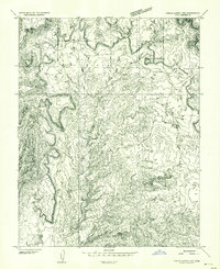
1953 Map of Circle Cliffs 1 NW
USGS Topo · Published 1954About this map
The Flats dominates the high-plateau landscape of this Garfield County interior during the early 1950s. This preliminary survey, based on 1952 aerial photography, captures a remote stretch of Utah's geologic heart before more permanent road networks were established. The terrain transitions from the broad expanse of White Canyon Flat in the southeast into the intricately carved drainages of Horse Canyon. Sparse but vital water improvements are documented, including several unnamed reservoirs marked simply as Dam and a solitary Seep, which likely served as critical watering points for local livestock in this arid environment. The landmark Lamp Stand stands as a prominent navigational point amidst the complex topography of ridges and canyons that define this portion of the Circle Cliffs region.
Find a feature on this map
6 named features on this map. Tap any name to fly to it.
Don’t see what you’re looking for? This feature index may not catch every label — zoom into the map to look around manually.
Map Details
Editions of this 1953 Circle Cliffs 1 NW Map
This is the sole edition of this map. No revisions or reprints were ever made.
Other maps of this area

1885 · Fish Lake
USGS Topo · 1:250,000

1886 · Escalante
USGS Topo · 1:250,000

1896 · Fish Lake
USGS Topo · 1:250,000

1952 · Notom 4 SE
USGS Topo · 1:24,000

1952 · Notom 4 SW
USGS Topo · 1:24,000

1952 · Notom 3 SE
USGS Topo · 1:24,000

1952 · Grover
USGS Topo · 1:62,500

1952 · Notom
USGS Topo · 1:62,500

1953 · Circle Cliffs 1 SE
USGS Topo · 1:24,000

1953 · Circle Cliffs 2 NE
USGS Topo · 1:24,000