
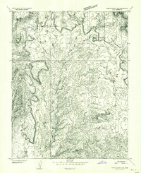
1953 Map of Circle Cliffs 2 NE
USGS Topo · Published 1954About this map
Dixie National Forest dominates this 1953 preliminary study of the Garfield County high country, revealing a landscape defined by dramatic elevation changes and sharp plateaus. The topography is anchored by the prominent Long Neck Mesa and the aptly named Impossible Peak, which towers over the northern reaches of the quadrangle. These features are separated by deep drainages such as The Gulch and Steep Creek, illustrating the natural barriers that once shaped movement through this part of southern Utah.
Find a feature on this map
10 named features on this map. Tap any name to fly to it.
Don’t see what you’re looking for? This feature index may not catch every label — zoom into the map to look around manually.
Map Details
Editions of this 1953 Circle Cliffs 2 NE Map
This is the sole edition of this map. No revisions or reprints were ever made.
Other maps of this area

1885 · Fish Lake
USGS Topo · 1:250,000

1886 · Escalante
USGS Topo · 1:250,000

1896 · Fish Lake
USGS Topo · 1:250,000

1952 · Notom 3 SW
USGS Topo · 1:24,000

1952 · Notom 4 SW
USGS Topo · 1:24,000

1952 · Notom 3 SE
USGS Topo · 1:24,000

1952 · Grover
USGS Topo · 1:62,500

1952 · Notom
USGS Topo · 1:62,500

1953 · Circle Cliffs 1 SW
USGS Topo · 1:24,000
1953 · Circle Cliffs 1 NW
USGS Topo · 1:24,000