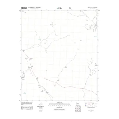
2011 Map of Circle Mesa
USGS Topo · Published 2011About this map
Allison Ranch and White Ranch anchor a landscape defined by ranching and small-scale mineral exploration in Grant County. The winding corridor of Mangas Creek provides the primary drainage for a network of complex canyons, including Saddle Rock Canyon and Haystack Canyon. This 2011 survey captures the distribution of legacy mining operations that dot the hillsides, notably the Wake-Up-Charlie Mine and the Pauline Mine near Treasure Mountain. The presence of several family-named ranch sites, such as Sherman Ranch and the J McMillen Ranch, alongside infrastructure like the Black Hawk Windmill, underscores the continuous agricultural and livestock use of the region. Transportation follows the natural contours of the land, with routes like Mangas Valley Rd and Wind Canyon Rd connecting remote high-altitude tanks and springs to the primary valley floor.
Find a feature on this map
43 named features on this map. Tap any name to fly to it.
Don’t see what you’re looking for? This feature index may not catch every label — zoom into the map to look around manually.
Map Details
Editions of this 2011 Circle Mesa Map
This is the sole edition of this map. No revisions or reprints were ever made.
Other maps of this area

1909 · Silver City
USGS Topo · 1:125,000

1949 · Circle Mesa
USGS Topo · 1:24,000

1950 · Tyrone
USGS Topo · 1:24,000

1950 · Dorsey Ranch
USGS Topo · 1:24,000

1950 · Wind Mountain
USGS Topo · 1:24,000

1950 · Silver City
USGS Topo · 1:24,000

1950 · Reading Mountain
USGS Topo · 1:24,000

1951 · Circle Mesa
USGS Topo · 1:24,000

1951 · Dorsey Ranch
USGS Topo · 1:24,000
1951 · Silver City
USGS Topo · 1:24,000