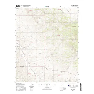
2017 Map of Circle Mesa
USGS Topo · Published 2017About this map
The Gila National Forest dominates this landscape, where the terrain transitions between the Big Burro Mountains and the Little Burro Mountains. This 2017 survey reveals a sophisticated network of drainage and transport through high-desert canyons, most notably along the Continental Divide National Scenic Trail as it traverses the southern half of the quadrangle. The elevation changes are marked by prominent features like Circle Mesa and Little Bear Mtn, while the seasonal water supply is evidenced by named improvements such as Dud Tank, Cane Spring, and Aqua Alta Tank.
Find a feature on this map
44 named features on this map. Tap any name to fly to it.
Don’t see what you’re looking for? This feature index may not catch every label — zoom into the map to look around manually.
Map Details
Editions of this 2017 Circle Mesa Map
This is the sole edition of this map. No revisions or reprints were ever made.
Other maps of this area

1909 · Silver City
USGS Topo · 1:125,000

1949 · Circle Mesa
USGS Topo · 1:24,000

1950 · Tyrone
USGS Topo · 1:24,000

1950 · Dorsey Ranch
USGS Topo · 1:24,000

1950 · Wind Mountain
USGS Topo · 1:24,000

1950 · Silver City
USGS Topo · 1:24,000

1950 · Reading Mountain
USGS Topo · 1:24,000

1951 · Circle Mesa
USGS Topo · 1:24,000

1951 · Dorsey Ranch
USGS Topo · 1:24,000
1951 · Silver City
USGS Topo · 1:24,000