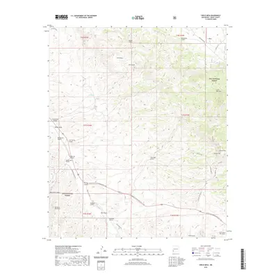
2020 Map of Circle Mesa
USGS Topo · Published 2020About this map
The Gila National Forest dominates this landscape in Grant County, where high mesa tops and deep drainages define the transition between the Big Burro Mountains and the Little Burro Mountains. The map traces a significant portion of the Continental Divide National Scenic Trail as it traverses the region, cutting through the southern portion of the sheet near Fleming Canyon. The drainage patterns of the Mangas Valley are clearly articulated, showing how Mangas Creek is fed by various seasonal sources including Ash Spring and Cane Spring.
Find a feature on this map
46 named features on this map. Tap any name to fly to it.
Don’t see what you’re looking for? This feature index may not catch every label — zoom into the map to look around manually.
Map Details
Editions of this 2020 Circle Mesa Map
This is the sole edition of this map. No revisions or reprints were ever made.
Other maps of this area

1909 · Silver City
USGS Topo · 1:125,000

1949 · Circle Mesa
USGS Topo · 1:24,000

1950 · Tyrone
USGS Topo · 1:24,000

1950 · Dorsey Ranch
USGS Topo · 1:24,000

1950 · Wind Mountain
USGS Topo · 1:24,000

1950 · Silver City
USGS Topo · 1:24,000

1950 · Reading Mountain
USGS Topo · 1:24,000

1951 · Circle Mesa
USGS Topo · 1:24,000

1951 · Dorsey Ranch
USGS Topo · 1:24,000
1951 · Silver City
USGS Topo · 1:24,000