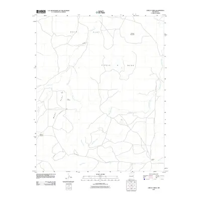
2010 Map of Circle S Mesa
USGS Topo · Published 2010About this map
West Cemetery and nearby Fish Ranch anchor this high-plains landscape in Quay County, where the topography transitions between broad plateaus and carved drainage basins. The area is defined by the massive Circle S Mesa to the east and the prominent peak of Pyramid Mountain in the northeast corner. This 2010 survey records a rural ranching environment where life revolves around water and access, evidenced by features like the Ham Windmill and the network of unpaved routes such as Quay Road 43. The land is dissected by numerous seasonal watercourses, including the winding Adobe Walls Creek and Wilson Creek, which drain the expansive West Flat and Ogle Flat. In the south, the terrain descends toward Garcia Creek and the rugged cut of Bogard Canyon, illustrating the varied elevations of the New Mexico mesa country.
Find a feature on this map
18 named features on this map. Tap any name to fly to it.
Don’t see what you’re looking for? This feature index may not catch every label — zoom into the map to look around manually.
Map Details
Editions of this 2010 Circle S Mesa Map
This is the sole edition of this map. No revisions or reprints were ever made.
Other maps of this area

1930 · Tucumcari
USGS Topo · 1:125,000

1954 · Santa Fe
USGS Topo · 1:250,000

1954 · Fort Sumner
USGS Topo · 1:250,000

1954 · Tucumcari
USGS Topo · 1:250,000

1954 · Clovis
USGS Topo · 1:250,000

1958 · Fort Sumner
USGS Topo · 1:250,000

1958 · Santa Fe
USGS Topo · 1:250,000

1958 · Clovis
USGS Topo · 1:250,000

1958 · Tucumcari
USGS Topo · 1:250,000
1964 · Montoya
USGS Topo · 1:24,000