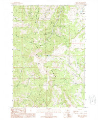
1988 Map of Cirque Lake
USGS Topo · Published 1989About this map
Mining operations and high mountain terrain define this corner of the Gravelly Range during the late twentieth century. Located within the Beaverhead National Forest, the Browns Gulch Mining District shows a landscape densely marked by extraction history, including the Kearsage Mine, General Shafter Mine, and Marietta Mine. Numerous adits, prospects, and mine shafts are scattered across the slopes of Greybacks Gulch and Hollow Gulch, indicating a legacy of intensive mineral exploration in the Madison County highlands.
Find a feature on this map
49 named features on this map. Tap any name to fly to it.
Don’t see what you’re looking for? This feature index may not catch every label — zoom into the map to look around manually.
Map Details
Editions of this 1988 Cirque Lake Map
This is the sole edition of this map. No revisions or reprints were ever made.
Other maps of this area

1888 · Three Forks
USGS Topo · 1:250,000

1893 · Dillon
USGS Topo · 1:250,000

1894 · Three Forks
USGS Topo · 1:250,000

1895 · Three Forks
USGS Topo · 1:250,000

1947 · Bozeman
USGS Topo · 1:250,000

1948 · Bozeman
USGS Topo · 1:250,000

1949 · Varney
USGS Topo · 1:62,500

1950 · Virginia City
USGS Topo · 1:62,500

1955 · Bozeman
USGS Topo · 1:250,000

1955 · Dillon
USGS Topo · 1:250,000