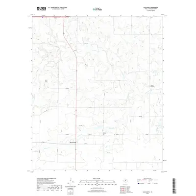
2019 Map of Cisco South
USGS Topo · Published 2019About this map
Cisco sits at the northern edge of this West Texas landscape, where the terrain begins to slope down toward the S Fork Leon River. The map captures a predominantly rural expanse of Eastland County defined by its watercourses and small community landmarks. In the southern portion of the sheet, the settlement of Pleasant Hill serves as a local hub near the winding path of Dead Horse Cr. Genealogy and local history researchers will find the locations of Pleasant Hill Cem and Pleasant Valley Cem particularly valuable for identifying family roots in the area. The presence of the Spring Ranch Airport and the network of county roads, including Co RD 180 and Co RD 190, illustrates the transport patterns of this ranching and farming country. To the east, Griffin Lake and the drainage of Greer Cr complete the hydrological profile of this prairie region.
Find a feature on this map
37 named features on this map. Tap any name to fly to it.
Don’t see what you’re looking for? This feature index may not catch every label — zoom into the map to look around manually.
Map Details
Editions of this 2019 Cisco South Map
This is the sole edition of this map. No revisions or reprints were ever made.
Other maps of this area

1894 · Eastland
USGS Topo · 1:125,000

1931 · Baird
USGS Topo · 1:125,000

1932 · Baird
USGS Topo · 1:125,000

1954 · Abilene
USGS Topo · 1:250,000

1958 · Abilene
USGS Topo · 1:250,000

1966 · Cisco North
USGS Topo · 1:24,000

1966 · Carbon
USGS Topo · 1:24,000

1966 · Scranton
USGS Topo · 1:24,000

1966 · Eastland
USGS Topo · 1:24,000
1966 · Bernie Lake
USGS Topo · 1:24,000