
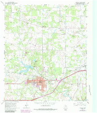
1966 Map of Eastland
USGS Topo · Published 1969About this map
The West Texas town of Eastland serves as the focal point of this mid-1960s study, situated where the Texas and Pacific railroad tracks bisect the community. The landscape is a hub of energy and transportation infrastructure, marked by the Lone Star Pumping Station and an extensive network of pipelines and oil wells that reach toward Morton Valley and Olden. The presence of an Old RR Grade running northwest from the city center suggests a changing rail landscape as old routes were superseded by modern corridors.
Find a feature on this map
32 named features on this map. Tap any name to fly to it.
Don’t see what you’re looking for? This feature index may not catch every label — zoom into the map to look around manually.
Map Details
Editions of this 1966 Eastland Map
2 editions found
Other maps of this area

1890 · Breckenridge
USGS Topo · 1:125,000

1894 · Eastland
USGS Topo · 1:125,000

1954 · Abilene
USGS Topo · 1:250,000

1958 · Abilene
USGS Topo · 1:250,000

1966 · Cisco North
USGS Topo · 1:24,000

1966 · Kokomo
USGS Topo · 1:24,000

1966 · Carbon
USGS Topo · 1:24,000

1966 · Cisco South
USGS Topo · 1:24,000

1966 · Ranger
USGS Topo · 1:24,000
1967 · Wayland
USGS Topo · 1:24,000