
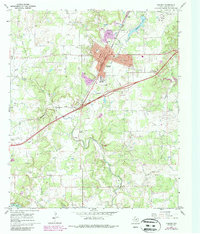
1966 Map of Ranger
USGS Topo · Published 1970About this map
Ranger and the surrounding Eastland County landscape appear here during a period of industrial activity and established civic life. The town is a focal point for regional infrastructure, evidenced by the Junior College, a Hospital, and the intersection of the Texas and Pacific railroad with local thoroughfares. To the west, the settlement of Olden sits along the rail line, while the northern boundary reaches the small community of Tiffin.
Find a feature on this map
45 named features on this map. Tap any name to fly to it.
Don’t see what you’re looking for? This feature index may not catch every label — zoom into the map to look around manually.
Map Details
Editions of this 1966 Ranger Map
2 editions found
Other maps of this area

1890 · Breckenridge
USGS Topo · 1:125,000

1894 · Eastland
USGS Topo · 1:125,000

1954 · Abilene
USGS Topo · 1:250,000

1958 · Abilene
USGS Topo · 1:250,000

1966 · Kokomo
USGS Topo · 1:24,000
1966 · Desdemona
USGS Topo · 1:24,000

1966 · Carbon
USGS Topo · 1:24,000
1966 · Bear Mountain
USGS Topo · 1:24,000

1966 · Eastland
USGS Topo · 1:24,000
1967 · Wayland
USGS Topo · 1:24,000