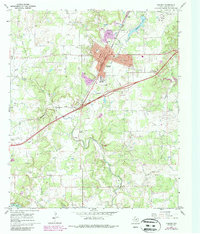
1966 Map of Ranger
USGS Topo · Published 1987About this map
Ranger serves as the focal point of this mid-century Texas landscape, where the Missouri Pacific railroad and a grid of streets including Main St and Commerce St define the local economy. The area's legacy as an oil-producing region is evident through the dense distribution of Oil Wells and a Pumping Sta scattered across the hills. Educational and social foundations are represented by Ranger Junior College and the Young Sch within the town limits.
Find a feature on this map
42 named features on this map. Tap any name to fly to it.
Don’t see what you’re looking for? This feature index may not catch every label — zoom into the map to look around manually.
Map Details
Editions of this 1966 Ranger Map
2 editions found
Other maps of this area

1890 · Breckenridge
USGS Topo · 1:125,000

1894 · Eastland
USGS Topo · 1:125,000

1954 · Abilene
USGS Topo · 1:250,000

1958 · Abilene
USGS Topo · 1:250,000

1966 · Kokomo
USGS Topo · 1:24,000
1966 · Desdemona
USGS Topo · 1:24,000

1966 · Carbon
USGS Topo · 1:24,000
1966 · Bear Mountain
USGS Topo · 1:24,000

1966 · Eastland
USGS Topo · 1:24,000

1966 · Ranger
USGS Topo · 1:24,000