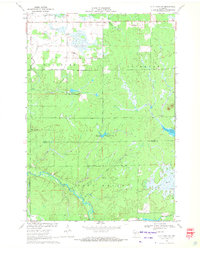
1970 Map of City Point NW
USGS Topo · Published 1972About this map
The East Fork Black River cuts a winding path through this central Wisconsin landscape, defined by its complex wetlands and low-lying drainages. In the southwestern corner, the small settlement of Pray sits near the river's Rapids, providing a focal point for local history along the border of Washburn and City Point. The terrain is dominated by water and marshland, evidenced by features such as the Amundson Marsh and an extensive Cranberry Bog, which reflect the region's long-standing agricultural and natural resource patterns.
Find a feature on this map
20 named features on this map. Tap any name to fly to it.
Don’t see what you’re looking for? This feature index may not catch every label — zoom into the map to look around manually.
Map Details
Editions of this 1970 City Point NW Map
2 editions found
Other maps of this area

1953 · Neillsville
USGS Topo · 1:62,500

1953 · Eau Claire
USGS Topo · 1:250,000

1954 · Granton
USGS Topo · 1:62,500

1957 · City Point
USGS Topo · 1:48,000

1958 · Eau Claire
USGS Topo · 1:250,000

1958 · Hatfield
USGS Topo · 1:48,000

1964 · Eau Claire
USGS Topo · 1:250,000

1970 · City Point NE
USGS Topo · 1:24,000

1970 · Spaulding
USGS Topo · 1:24,000
1970 · City Point
USGS Topo · 1:24,000