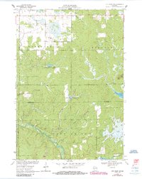
1970 Map of City Point NW
USGS Topo · Published 1985About this map
The East Fork Black River cuts a winding path through this central Wisconsin landscape, defining the transition between the Washburn and City Point regions. Surveyed in 1969 and updated in the mid-1980s, the map reveals a terrain heavily shaped by water and low-lying wetlands, including the expansive Ammundson Marsh and a notable Cranberry Bog near the southern boundary. Small-scale industrial activity is evident in the scattered Gravel Pits and a Sandpit, likely supporting local road infrastructure during this era.
Find a feature on this map
18 named features on this map. Tap any name to fly to it.
Don’t see what you’re looking for? This feature index may not catch every label — zoom into the map to look around manually.
Map Details
Editions of this 1970 City Point NW Map
2 editions found
Other maps of this area

1953 · Neillsville
USGS Topo · 1:62,500

1953 · Eau Claire
USGS Topo · 1:250,000

1954 · Granton
USGS Topo · 1:62,500

1957 · City Point
USGS Topo · 1:48,000

1958 · Eau Claire
USGS Topo · 1:250,000

1958 · Hatfield
USGS Topo · 1:48,000

1964 · Eau Claire
USGS Topo · 1:250,000

1970 · City Point NE
USGS Topo · 1:24,000

1970 · Spaulding
USGS Topo · 1:24,000
1970 · City Point
USGS Topo · 1:24,000