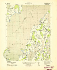
1943 Map of Claiborne
USGS Topo · Published 1943About this map
Harris Creek and Eastern Bay define this wartime portrait of Maryland's Eastern Shore, where the land is deeply feathered by tidal coves and necks. The maritime economy of the early 1940s is evident in the alignment of the Claiborne-Romancoke Ferry and the presence of Lowes Wharf. Small settlements like Wittman and Sherwood serve as local hubs, anchored by community institutions such as St Johns Church and the Wittman Sch.
Find a feature on this map
52 named features on this map. Tap any name to fly to it.
Don’t see what you’re looking for? This feature index may not catch every label — zoom into the map to look around manually.
Map Details
Editions of this 1943 Claiborne Map
This is the sole edition of this map. No revisions or reprints were ever made.
Other maps of this area

1892 · Annapolis
USGS Topo · 1:62,500

1893 · Sharps Island
USGS Topo · 1:62,500

1898 · Choptank
USGS Topo · 1:125,000

1904 · St. Michaels
USGS Topo · 1:62,500

1904 · Annapolis
USGS Topo · 1:62,500

1904 · Sharps Island
USGS Topo · 1:62,500

1904 · Oxford
USGS Topo · 1:62,500

1908 · Choptank
USGS Topo · 1:125,000

1942 · Tilghman
USGS Topo · 1:31,680

1942 · Oxford
USGS Topo · 1:31,680