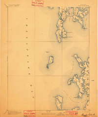
1893 Map of Sharps Island
USGS Topo · Published 1901About this map
Sharps Island sits at the center of this maritime survey, illustrating the fragile geography of the Chesapeake Bay in the late 19th century. Positioned between Talbot and Dorchester counties, the map captures a period of intense coastal activity before rising waters significantly reshaped these landmasses. Along the northern shoreline, the fishing village of Tilghman on Tilghman Island is accessible via the Knapp Narrows, while the settlement of Neavitt serves as a small hub for the interior peninsulas between Harris Creek and Broad Creek. To the south, the intricate coast of Dorchester County is defined by the Little Choptank River and Trippe Bay. The presence of the Sharps I. Light underscores the importance of this navigation hazard for vessels moving between the open bay and the numerous coves like Pawpaw Cove and Brannock Bay.
Find a feature on this map
39 named features on this map. Tap any name to fly to it.
Don’t see what you’re looking for? This feature index may not catch every label — zoom into the map to look around manually.
Map Details
Editions of this 1893 Sharps Island Map
3 editions found
Other maps of this area

1892 · Leonardtown
USGS Topo · 1:62,500

1892 · Drum Point
USGS Topo · 1:62,500

1892 · Prince Frederick
USGS Topo · 1:62,500

1892 · Owensville
USGS Topo · 1:62,500

1892 · Annapolis
USGS Topo · 1:62,500

1893 · Sharps Island
USGS Topo · 1:62,500

1895 · Prince Frederick
USGS Topo · 1:62,500

1895 · Leonardtown
USGS Topo · 1:62,500

1895 · Nomini
USGS Topo · 1:125,000

1895 · Owensville
USGS Topo · 1:62,500