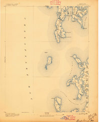
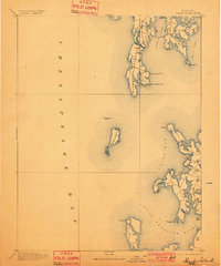
1893 Map of Sharps Island
USGS Topo · Published 1896About this map
Sharps Island stands at the center of this late 19th-century hydrographic study, showing the landform as it existed decades before it was reclaimed by the tides of the Chesapeake Bay. The map records the crucial navigational aid at Sharps I. Light, marking the passage between the bay and the Little Choptank River. To the north, the maritime geography of Talbot is defined by the intricate shoreline of Tilghman Island and the bustling passage at Knapp Narrows.
Find a feature on this map
40 named features on this map. Tap any name to fly to it.
Don’t see what you’re looking for? This feature index may not catch every label — zoom into the map to look around manually.
Map Details
Editions of this 1893 Sharps Island Map
3 editions found
Other maps of this area

1892 · Leonardtown
USGS Topo · 1:62,500

1892 · Drum Point
USGS Topo · 1:62,500

1892 · Prince Frederick
USGS Topo · 1:62,500

1892 · Owensville
USGS Topo · 1:62,500

1892 · Annapolis
USGS Topo · 1:62,500

1893 · Sharps Island
USGS Topo · 1:62,500

1895 · Prince Frederick
USGS Topo · 1:62,500

1895 · Leonardtown
USGS Topo · 1:62,500

1895 · Nomini
USGS Topo · 1:125,000

1895 · Owensville
USGS Topo · 1:62,500