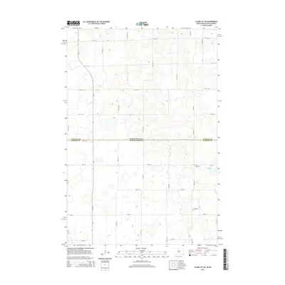
2014 Map of Claire City NE
USGS Topo · Published 2014About this map
North Dakota and South Dakota meet along a straight surveyor’s line in this 2014 study of the borderlands between Richland and Roberts counties. The landscape is defined by the high-plains section line grid, where gravel routes like Co Road 22 and 158th Ave SE crisscross a terrain dotted with prairie potholes and small depressions. This rural expanse preserves long-standing community landmarks such as Saint Pauls Cem and Ferkingstad Cem, which serve as primary anchors for local genealogy. The natural drainage of the region is traced through the slow-moving waters of Indian Slough and the winding course of the L Minnesot a R at the southern edge, illustrating the subtle hydrology of the Red River Valley’s western margins.
Find a feature on this map
34 named features on this map. Tap any name to fly to it.
Don’t see what you’re looking for? This feature index may not catch every label — zoom into the map to look around manually.
Map Details
Editions of this 2014 Claire City NE Map
This is the sole edition of this map. No revisions or reprints were ever made.
Other maps of this area

1904 · Wahpeton
USGS Topo · 1:125,000

1907 · Wyndmere
USGS Topo · 1:125,000

1917 · New Effington
USGS Topo · 1:62,500

1953 · Milbank
USGS Topo · 1:250,000

1953 · Fargo
USGS Topo · 1:250,000

1956 · Fargo
USGS Topo · 1:250,000

1958 · Milbank
USGS Topo · 1:250,000

1964 · Hankinson
USGS Topo · 1:24,000
1964 · Lidgerwood
USGS Topo · 1:24,000
1964 · Swan Lake
USGS Topo · 1:24,000