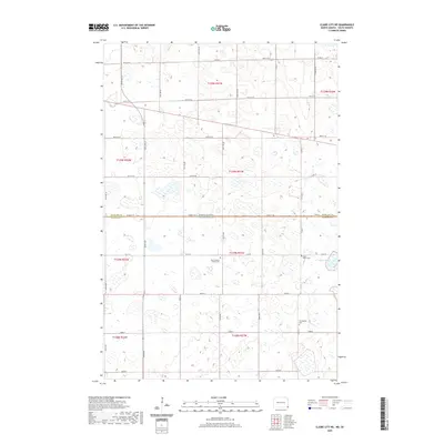
2020 Map of Claire City NE
USGS Topo · Published 2020About this map
North Dakota and South Dakota meet along a surveyed boundary line that also separates Richland and Roberts counties on this 2020 map. The landscape is defined by an extensive network of wetlands and small water bodies, including the notable Indian Slough in the eastern section. This agrarian region is anchored by traditional community landmarks that serve as vital records for family historians. These include the Zion Lutheran Church Cem and Saint Paul's Cem, which sit just north of the state line, and the Ferkingstad Cem to the south. The area is laid out in a strict section grid, with local travel facilitated by roads such as Co Rd 22 and 102nd St SE that follow the township and range lines of the Public Land Survey System.
Find a feature on this map
25 named features on this map. Tap any name to fly to it.
Don’t see what you’re looking for? This feature index may not catch every label — zoom into the map to look around manually.
Map Details
Editions of this 2020 Claire City NE Map
This is the sole edition of this map. No revisions or reprints were ever made.
Other maps of this area

1904 · Wahpeton
USGS Topo · 1:125,000

1907 · Wyndmere
USGS Topo · 1:125,000

1917 · New Effington
USGS Topo · 1:62,500

1953 · Milbank
USGS Topo · 1:250,000

1953 · Fargo
USGS Topo · 1:250,000

1956 · Fargo
USGS Topo · 1:250,000

1958 · Milbank
USGS Topo · 1:250,000

1964 · Hankinson
USGS Topo · 1:24,000
1964 · Lidgerwood
USGS Topo · 1:24,000
1964 · Swan Lake
USGS Topo · 1:24,000