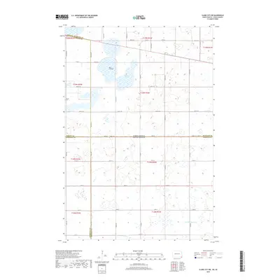
2018 Map of Claire City NW
USGS Topo · Published 2018About this map
Bergen Cem stands in the northwestern corner of this prairie landscape, a testament to the early Scandinavian settlement patterns that defined the borderlands between North Dakota and South Dakota. The terrain is characterized by a high density of wetlands and glacial depressions, including the prominent Kennedy Slough and the Park Lakebed. To the south, the headwaters of the Little Minnesota River begin their course, carving a subtle path through the agricultural grid. This 2018 survey reveals a modern rural landscape where the Jeffersonian survey system dictates the road network, as seen in the alignment of Co Rd 19 and Co Rd 22. The map captures the intersection of four different counties—Sargent and Richland in North Dakota, and Marshall and Roberts in South Dakota—illustrating the complex jurisdictional boundaries at this tri-state junction.
Find a feature on this map
41 named features on this map. Tap any name to fly to it.
Don’t see what you’re looking for? This feature index may not catch every label — zoom into the map to look around manually.
Map Details
Editions of this 2018 Claire City NW Map
This is the sole edition of this map. No revisions or reprints were ever made.
Other maps of this area

1907 · Wyndmere
USGS Topo · 1:125,000

1953 · Milbank
USGS Topo · 1:250,000

1953 · Fargo
USGS Topo · 1:250,000

1956 · Fargo
USGS Topo · 1:250,000

1958 · Milbank
USGS Topo · 1:250,000

1958 · Veblen
USGS Topo · 1:24,000

1958 · Veblen NE
USGS Topo · 1:24,000

1958 · Geneseo
USGS Topo · 1:24,000
1964 · Lidgerwood
USGS Topo · 1:24,000
1964 · Swan Lake
USGS Topo · 1:24,000