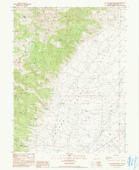
1990 Map of Clan Alpine Ranch
USGS Topo · Published 1990About this map
The Clan Alpine Mountains dominate the western landscape of this 1990 provisional survey, giving way to the expansive Edwards Valley to the east. This transition from high peaks to valley floor is marked by historical remnants of settlement and industry, most notably at Clan Alpine (Ruins) and the Clan Alpine Ranch. Evidence of mineral exploration appears at the Tungsten Williams Mine and several gravel pits, while the presence of a Corral and numerous wells indicates a reliance on the sparse water sources of this high desert environment.
Find a feature on this map
21 named features on this map. Tap any name to fly to it.
Don’t see what you’re looking for? This feature index may not catch every label — zoom into the map to look around manually.
Map Details
Editions of this 1990 Clan Alpine Ranch Map
This is the sole edition of this map. No revisions or reprints were ever made.
Other maps of this area

1955 · Millett
USGS Topo · 1:250,000

1959 · Millett
USGS Topo · 1:250,000

1966 · Clan Alpine Ranch
USGS Topo · 1:62,500

1966 · Edwards Creek Valley
USGS Topo · 1:62,500

1969 · Camp Creek Canyon
USGS Topo · 1:24,000

1969 · Cold Springs
USGS Topo · 1:24,000

1969 · Basque Summit
USGS Topo · 1:24,000

1983 · Edwards Creek Valley
USGS Topo · 1:100,000

1985 · Smith Creek Valley
USGS Topo · 1:100,000

1990 · Byers Ranch
USGS Topo · 1:24,000