1986 Map of Clanton
USGS Topo · Published 1986About this map
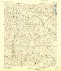
The Coosa River corridor defines this mid-1980s landscape, where its dammed waters create the sprawling Mitchell Lake and Jordan Lake. This planimetric study captures the rural geography of Central Alabama, anchored by the county seat at Clanton and the smaller junctions of Jemison, Thorsby, and Verbena. A significant archaeological and historical footprint is evident at the southern confluence near Wetumpka, where Fort Toulouse National Historic Park marks a site of colonial and indigenous importance, further underscored by the presence of the Old Indian Treaty Boundary.
Find a feature on this map
184 named features on this map. Tap any name to fly to it.
Don’t see what you’re looking for? This feature index may not catch every label — zoom into the map to look around manually.
Map Details
Editions of this 1986 Clanton Map
This is the sole edition of this map. No revisions or reprints were ever made.
Historical Maps of Prattville Through Time
3 maps found