
Loading...
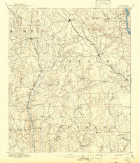
Loading map...1987 Map of Clanton
USGS Topo · Published 1990About this map
Coosa River hydrologic engineering defines the central corridor of this region, where the Lay Lake, Mitchell Lake, and Jordan Lake reservoirs follow the winding path of the river through central Alabama. The landscape transitions from the southern reaches of the Talladega National Forest in the west to the dense woodlands of the Coosa Wildlife Management Area and Wessobulga State Forest in the east.
Find a feature on this map
217 named features on this map. Tap any name to fly to it.
Don’t see what you’re looking for? This feature index may not catch every label — zoom into the map to look around manually.
Map Details
Date Portrayed1987
Date Published1990
PublisherU.S. Geological Survey
Map TypeTopographic
Scale1:100,000
Physical Dimensions43.1 x 24 inches
Editions of this 1987 Clanton Map
This is the sole edition of this map. No revisions or reprints were ever made.
Historical Maps of Prattville Through Time
3 maps found

Featured Locations
Source Details
SourceU.S. Geological Survey
CopyrightPublic Domain