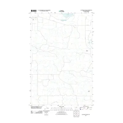
2011 Map of Clanton Coulee
USGS Topo · Published 2011About this map
Strater and its Strater Post Office anchor the northwestern corner of this Phillips County landscape, situated where the high plains meet a complex system of drainage and waterfowl habitat. The northern border is defined by the significant waters of Lake Bowdoin and Goose Island Pond, providing a stark contrast to the intricate network of coulees that carve through the southern terrain. This map reveals a land shaped by intermittent water and sparse settlement, where named features like Clanton Coulee and LeNoir Coulee dictate the local geography. Small-scale water management is evident at the LeNoir Reservoir, while local transit relies on a modest grid of thoroughfares including Bowdoin Rd and Harbor Rd, reflecting the quiet ranching and agricultural character of this Montana region in the early 21st century.
Find a feature on this map
9 named features on this map. Tap any name to fly to it.
Don’t see what you’re looking for? This feature index may not catch every label — zoom into the map to look around manually.
Map Details
Editions of this 2011 Clanton Coulee Map
This is the sole edition of this map. No revisions or reprints were ever made.
Other maps of this area

1905 · Bowdoin
USGS Topo · 1:62,500

1954 · Glasgow
USGS Topo · 1:250,000

1957 · Glasgow
USGS Topo · 1:250,000

1958 · Glasgow
USGS Topo · 1:250,000
1968 · Malta NE
USGS Topo · 1:24,000

1968 · Malta East
USGS Topo · 1:24,000

1984 · Clanton Coulee
USGS Topo · 1:24,000

1984 · Pinks
USGS Topo · 1:24,000
1984 · Bowdoin
USGS Topo · 1:24,000
1984 · Lake Bowdoin
USGS Topo · 1:24,000