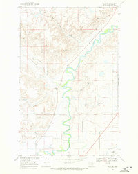
1968 Map of Malta NE
USGS Topo · Published 1971About this map
The Milk River meanders across this northern Montana landscape, its serpentine path defining the drainage patterns for numerous coulees including Horse Camp Coulee, Spring Coulee, and Delaney Coulee. Mapped in the late 1960s as part of the Department of the Interior program for the development of the Missouri River Basin, the topography reveals a reliance on water management and seasonal watercourses. Near the southern edge, the Dodson South Canal runs parallel to the river, indicating the complex irrigation infrastructure supporting local agriculture. Rural life is anchored by landmarks like the Circle Diamond Sch and Strater Hall in the southeast corner. The presence of Assiniboine Creek and a localized Gravel Pit further characterize the area's geography, where the dry creek beds and coulees carve through the terrain toward the river valley.
Find a feature on this map
15 named features on this map. Tap any name to fly to it.
Don’t see what you’re looking for? This feature index may not catch every label — zoom into the map to look around manually.
Map Details
Editions of this 1968 Malta NE Map
This is the sole edition of this map. No revisions or reprints were ever made.
Other maps of this area

1905 · Bowdoin
USGS Topo · 1:62,500

1920 · Cowan
USGS Topo · 1:125,000

1954 · Glasgow
USGS Topo · 1:250,000

1957 · Glasgow
USGS Topo · 1:250,000

1958 · Glasgow
USGS Topo · 1:250,000

1968 · Malta West
USGS Topo · 1:24,000

1968 · Hewitt Lake SW
USGS Topo · 1:24,000

1968 · Malta East
USGS Topo · 1:24,000
1968 · Malta NW
USGS Topo · 1:24,000

1984 · Clanton Coulee
USGS Topo · 1:24,000