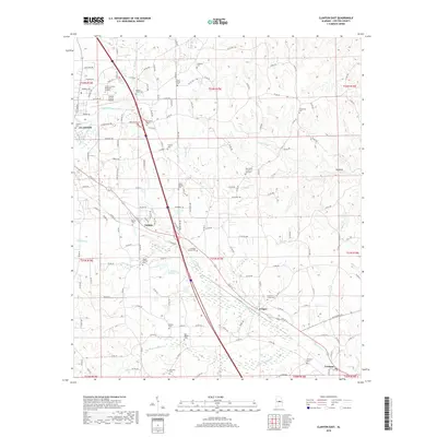
2018 Map of Clanton East
USGS Topo · Published 2018About this map
Clanton serves as the focal point for this survey of Chilton County, where the landscape is defined by the winding course of Walnut Creek and its many tributaries. The area exhibits a dense concentration of local history markers, particularly seen in the numerous family and community burial grounds such as the Aldridge Family Cem and Oak Grove Church of God Cem. The map tracks the interstate corridor south through settlements like Falakto and Cooper toward Verbena, illustrating the infrastructure that connects these rural communities. Notable water features include Shelton Barkley Lake and T J Stewart Lake, which sit alongside the extensive drainage systems of Chestnut Cr and Cargle Cr. The presence of the Chilton County Airport near Chilton County Memorial Gardens indicates the modernization of the county seat's outskirts during this era.
Find a feature on this map
62 named features on this map. Tap any name to fly to it.
Don’t see what you’re looking for? This feature index may not catch every label — zoom into the map to look around manually.
Map Details
Editions of this 2018 Clanton East Map
This is the sole edition of this map. No revisions or reprints were ever made.
Other maps of this area

1891 · Clanton
USGS Topo · 1:125,000

1901 · Wetumpka
USGS Topo · 1:125,000

1903 · Wetumpka
USGS Topo · 1:125,000

1953 · Montgomery
USGS Topo · 1:250,000

1956 · Montgomery
USGS Topo · 1:250,000

1957 · Montgomery
USGS Topo · 1:250,000

1959 · Billingsley
USGS Topo · 1:62,500

1959 · Elmore
USGS Topo · 1:62,500
1971 · Mitchell Dam NW
USGS Topo · 1:24,000
1971 · Mitchell Dam
USGS Topo · 1:24,000