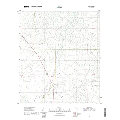
2018 Map of Clara
USGS Topo · Published 2018About this map
The Steinhatchee River flows through a landscape defined by its hydrology and remote timberlands at the intersection of Taylor, Lafayette, and Dixie Counties. This 2018 survey reveals the dispersed settlement patterns of the Big Bend region, centering on the communities of Clara and Tennille. The terrain is characterized by a dense network of forest roads and canal segments, such as S Canal Rd, which intersect the wet flatwoods and wetlands. Significant natural features include Steinhatchee Spring and Iron Spring, indicating the karst-influenced drainage of the area. To the northeast, the sprawling Mud Swamp and Mud Cr illustrate the low-lying, poorly drained environment that has historically shaped local land use. Local transport is facilitated by a grid of numbered forest roads and tracks like Jones Grade Rd and Deer Run Rd, providing access through the heavily forested sections of t7s r10e and surrounding townships.
Find a feature on this map
73 named features on this map. Tap any name to fly to it.
Don’t see what you’re looking for? This feature index may not catch every label — zoom into the map to look around manually.
Map Details
Editions of this 2018 Clara Map
This is the sole edition of this map. No revisions or reprints were ever made.
Other maps of this area

1954 · Mallory Swamp NW
USGS Topo · 1:24,000

1954 · Cross City West
USGS Topo · 1:24,000

1954 · Clara
USGS Topo · 1:24,000

1954 · Salem SW
USGS Topo · 1:24,000

1954 · Mallory Swamp SW
USGS Topo · 1:24,000

1954 · Jena
USGS Topo · 1:24,000

1954 · Cooks Hammock
USGS Topo · 1:24,000

1954 · Salem
USGS Topo · 1:24,000

1954 · Steinhatchee
USGS Topo · 1:24,000

1954 · Gainesville
USGS Topo · 1:250,000