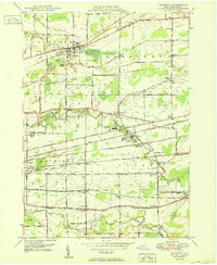
1950 Map of Clarence
USGS Topo · Published 1950About this map
Clarence and the surrounding townships in Erie County reveal a landscape shaped by early-century industrial transport and community infrastructure just after the war. The rail network is particularly dense, with the New York Central, Lehigh Valley, and Lackawanna and Western lines crossing the terrain to serve stations such as Marilla Sta and Town Line Sta. These railroads cut through a landscape of creek bottoms, notably Ellicott Creek and Cayuga Creek, where small settlements like Mill Grove and Wende developed around institutional landmarks including the County Home and Infirmary and the County Penitentiary.
Find a feature on this map
70 named features on this map. Tap any name to fly to it.
Don’t see what you’re looking for? This feature index may not catch every label — zoom into the map to look around manually.
Map Details
Editions of this 1950 Clarence Map
This is the sole edition of this map. No revisions or reprints were ever made.
Other maps of this area

1897 · Medina
USGS Topo · 1:62,500

1897 · Lockport
USGS Topo · 1:62,500

1899 · Niagara
USGS Topo · 1:125,000

1902 · Lockport
USGS Topo · 1:62,500

1905 · Attica
USGS Topo · 1:62,500

1905 · Depew
USGS Topo · 1:62,500

1905 · Lockport
USGS Topo · 1:62,500

1948 · Depew
USGS Topo · 1:62,500

1948 · Lockport
USGS Topo · 1:62,500

1949 · Attica
USGS Topo · 1:62,500