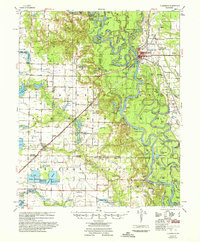
1957 Map of Clarendon
USGS Topo · Published 1957About this map
The White River and Cache River confluence anchors this 1950s survey of the Arkansas Delta, where the town of Clarendon serves as a vital river and rail hub. The landscape is defined by an intricate network of oxbow lakes and bayous, including Big Weidmann Lake, Round Pond, and Rock Roe Bayou, reflecting the heavy influence of seasonal flooding on settlement patterns. Beyond the river bottoms, the map meticulously records the rural social fabric of Monroe, Arkansas, and Prairie counties through numerous country churches and burial grounds like Pleasant Home Ch & Cem and Hunters Chapel & Cem. Industrial and transport history is visible at the Ramsey Mill Site and along the St Louis Southwestern railroad line, which features the Audrich Switch. Small communities like Roe, Duncan, and Casscoe are connected by a system of roads and agricultural flumes, illustrating the mid-century transition of this fertile timber and farming region.
Find a feature on this map
114 named features on this map. Tap any name to fly to it.
Don’t see what you’re looking for? This feature index may not catch every label — zoom into the map to look around manually.
Map Details
Editions of this 1957 Clarendon Map
This is the sole edition of this map. No revisions or reprints were ever made.
Other maps of this area

1935 · Hazen
USGS Topo · 1:62,500

1935 · Clarendon
USGS Topo · 1:62,500

1937 · Stuttgart
USGS Topo · 1:62,500

1939 · Indian Bay
USGS Topo · 1:62,500

1939 · Stuttgart
USGS Topo · 1:62,500

1940 · Holly Grove
USGS Topo · 1:62,500

1940 · Brinkley
USGS Topo · 1:62,500

1941 · Hazen
USGS Topo · 1:62,500

1941 · De Witt
USGS Topo · 1:62,500

1941 · De Valls Bluff
USGS Topo · 1:62,500