
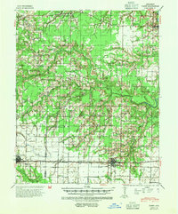
1941 Map of Hazen
USGS Topo · Published 1942About this map
The Chicago Rock Island and Pacific railroad forms a distinct industrial corridor across this 1941 landscape, anchoring the principal settlements of Carlisle and Hazen. This era in Prairie County and Lonoke County is defined by a dense network of rural infrastructure, where nearly every township is served by its own community hub, such as the Brown Grove Sch or Johnson Chapel. The terrain is deeply etched by the winding course of the Wattensaw Bayou and Two Prairie Bayou, which dictated the early settlement patterns and the placement of ferries and fords.
Find a feature on this map
85 named features on this map. Tap any name to fly to it.
Don’t see what you’re looking for? This feature index may not catch every label — zoom into the map to look around manually.
Map Details
Editions of this 1941 Hazen Map
2 editions found
Other maps of this area

1932 · Kensett
USGS Topo · 1:62,500

1935 · Kensett
USGS Topo · 1:62,500

1935 · Hazen
USGS Topo · 1:62,500

1935 · Clarendon
USGS Topo · 1:62,500

1935 · Gregory
USGS Topo · 1:62,500

1937 · Stuttgart
USGS Topo · 1:62,500

1937 · England
USGS Topo · 1:48,000

1939 · Stuttgart
USGS Topo · 1:62,500

1940 · Lonoke
USGS Topo · 1:62,500

1941 · De Valls Bluff
USGS Topo · 1:62,500