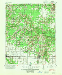
1941 Map of Hazen
USGS Topo · Published 1954About this map
The Chicago Rock Island and Pacific RR anchors the southern landscape of this 1941 survey, connecting the towns of Carlisle and Hazen. This corridor reflects the agricultural and transportation heart of the Grand Prairie region, where the rail line runs parallel to U. S. Route 70. The surrounding rural landscape is remarkably dense with community landmarks, particularly schools and churches that served as local hubs. These include unique dual-purpose sites such as Hickory Plains Ch Sch & Cem and Pinch Sch & Ch.
Find a feature on this map
64 named features on this map. Tap any name to fly to it.
Don’t see what you’re looking for? This feature index may not catch every label — zoom into the map to look around manually.
Map Details
Editions of this 1941 Hazen Map
2 editions found
Other maps of this area

1932 · Kensett
USGS Topo · 1:62,500

1935 · Kensett
USGS Topo · 1:62,500

1935 · Hazen
USGS Topo · 1:62,500

1935 · Clarendon
USGS Topo · 1:62,500

1935 · Gregory
USGS Topo · 1:62,500

1937 · Stuttgart
USGS Topo · 1:62,500

1937 · England
USGS Topo · 1:48,000

1939 · Stuttgart
USGS Topo · 1:62,500

1940 · Lonoke
USGS Topo · 1:62,500

1941 · Hazen
USGS Topo · 1:62,500