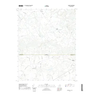
2019 Map of Claresville
USGS Topo · Published 2019About this map
Claresville sits at the northern edge of this landscape where the Virginia and North Carolina border divides the coastal plain. The terrain is defined by a dense network of wetlands and slow-moving water, with Fountains Creek and Cypress Creek winding through the southern half. These hydrologic features are flanked by significant marshlands including Mill Swamp, Caney Swamp, and Jacks Swamp, which have historically dictated the placement of roads and small agricultural settlements.
Find a feature on this map
40 named features on this map. Tap any name to fly to it.
Don’t see what you’re looking for? This feature index may not catch every label — zoom into the map to look around manually.
Map Details
Editions of this 2019 Claresville Map
This is the sole edition of this map. No revisions or reprints were ever made.
Other maps of this area

1919 · Emporia
USGS Topo · 1:62,500

1919 · Arringdale
USGS Topo · 1:48,000

1920 · Arringdale
USGS Topo · 1:62,500

1942 · Arringdale
USGS Topo · 1:62,500

1942 · Emporia
USGS Topo · 1:62,500

1953 · Norfolk
USGS Topo · 1:250,000

1963 · Skippers
USGS Topo · 1:24,000

1963 · Emporia
USGS Topo · 1:24,000
1966 · Drewryville
USGS Topo · 1:24,000

1966 · Margarettsville
USGS Topo · 1:24,000