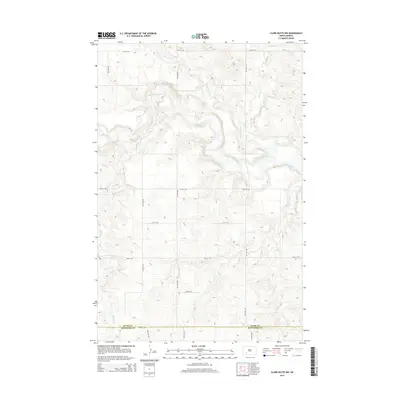
2014 Map of Clark Butte NW
USGS Topo · Published 2014About this map
The Heart River winds through the northern portion of this landscape, carving a distinctive valley through the prairie uplands of southwestern North Dakota. In this rural expanse during the early 21st century, the terrain is defined by its drainage systems, including the headwaters and tributaries of Government Cr and Spring Cr. The southern boundary of the map follows the straight-line political division of Stark Co and Hettinger Co, a marker typical of the region’s rectilinear section-line grid. This grid is further established by a network of rural routes such as 85th Ave SW and 50th St SW, which provide access across the rolling breaks and plateaus. In the southwestern corner, Buffalo Cr cuts through the high ground, illustrating the subtle but complex hydrology that directs water toward the Missouri River basin.
Find a feature on this map
16 named features on this map. Tap any name to fly to it.
Don’t see what you’re looking for? This feature index may not catch every label — zoom into the map to look around manually.
Map Details
Editions of this 2014 Clark Butte NW Map
This is the sole edition of this map. No revisions or reprints were ever made.
Other maps of this area

1953 · Dickinson
USGS Topo · 1:250,000

1957 · Dickinson
USGS Topo · 1:250,000

1960 · Clark Butte NW
USGS Topo · 1:24,000

1960 · Clark Butte NE
USGS Topo · 1:24,000

1960 · White Butte NE
USGS Topo · 1:24,000

1960 · Clark Butte SW
USGS Topo · 1:24,000

1960 · White Butte East
USGS Topo · 1:24,000

1960 · Clark Butte
USGS Topo · 1:24,000
1973 · Hebron SE
USGS Topo · 1:24,000

1973 · Richardton SE
USGS Topo · 1:24,000